![](/images/other/stat-length.png)
![Randonnée Marche Le Revest-les-Eaux - Stade du Revest / Grand Cap - Photo](https://media.geolcdn.com/t/1900/400/ext.pjpeg?maxdim=2&url=https%3A%2F%2Fservices.sitytrail.com%2FGeolivesWS%2FDownloadMedia.ashx%3FTrailID%3D261079%26Media%3Dfix__20140327111758.jpg)
Stade du Revest / Grand Cap
francisdean
Utilisateur
![Longueur](/images/other/stat-length.png)
Longueur
12 km
![Altitude max](https://static1.geolcdn.com/siteimages/upload/files/1508320355ic_sort_altitude_max_24dp.png)
Altitude max
779 m
![Dénivelé positif](https://static1.geolcdn.com/siteimages/upload/files/1508320355ic_sort_den_pos_24dp.png)
Dénivelé positif
507 m
![Km-Effort](/images/other/stat-length.png)
Km-Effort
18,7 km
![Altitude min](https://static1.geolcdn.com/siteimages/upload/files/1508320355ic_sort_altitude_min_24dp.png)
Altitude min
277 m
![Dénivelé négatif](https://static1.geolcdn.com/siteimages/upload/files/1508320355ic_sort_den_neg_24dp.png)
Dénivelé négatif
512 m
![Boucle](https://static1.geolcdn.com/siteimages/upload/files/16400158638029165_repeat_loop_refresh_sync_direction_icon.png)
Boucle
Oui
Date de création :
2014-12-10 00:00:00.0
Dernière modification :
2014-12-10 00:00:00.0
![Marche](https://static1.geolcdn.com/sitytour/trail-icons/101.png)
3h53
Difficulté : Facile
![Scannez ce code QR pour ouvrir la randonnée dans l'application SityTrail](https://capi.geolives.com/qq0zvz2zws4bq2lad0pu/sitytour/trails/261079/qr.png?size=200)
Application GPS de randonnée GRATUITE
À propos
Randonnée Marche de 12 km à découvrir à Provence-Alpes-Côte d'Azur, Var, Le Revest-les-Eaux. Cette randonnée est proposée par francisdean.
Description
Prendre le GR 99 au stade du Revest et le suivre jusqu'a la citerne. Prendre le trace Bleu jusqu'au sommet du Grand Cap. Splendide point de vue. Continuez sur le tracé bleu puis jaune qui vous ramene au stade.
Localisation
Pays :
France
Région :
Provence-Alpes-Côte d'Azur
Département/Province :
Var
Commune :
Le Revest-les-Eaux
Localité :
Unknown
Départ:(Dec)
Départ:(UTM)
737688 ; 4785381 (31T) N.
Commentaires
Randonnées à proximité
![Randonnée Marche Ollioules - Chateau Vallon - Oppidum - Meulerie - Grotte patrimoine - vallon du Destel - Grotte des Joncs 9 - Four à cade - Appier - Four à chaux - Photo](https://media.geolcdn.com/t/375/260/b00c002a-3425-4f84-ae24-7620ef9e7315.jpg&format=jpg&maxdim=2)
![Marche Marche](https://static1.geolcdn.com/sitytour/trail-icons/101.png)
Chateau Vallon - Oppidum - Meulerie - Grotte patrimoine - vallon du Destel - ...
Marche
Moyen
(1)
Ollioules,
Provence-Alpes-Côte d'Azur,
Var,
France
![](/images/other/stat-length.png)
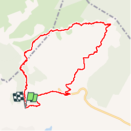
11,8 km | 19,3 km-effort
4h 23min
![](https://static1.geolcdn.com/siteimages/upload/files/16400158638029165_repeat_loop_refresh_sync_direction_icon.png)
Oui
![Randonnée Marche Solliès-Toucas - Les Morières - les bidoufles - Valbelle - la Garoute - la Baume des Lumes - La grotte des lumes - Photo](https://media.geolcdn.com/t/375/260/3e6ddcf9-f59d-47f4-a0ee-582c12a1d8d8.jpg&format=jpg&maxdim=2)
![Marche Marche](https://static1.geolcdn.com/sitytour/trail-icons/101.png)
Les Morières - les bidoufles - Valbelle - la Garoute - la Baume des Lumes - L...
Marche
Facile
(1)
Solliès-Toucas,
Provence-Alpes-Côte d'Azur,
Var,
France
![](/images/other/stat-length.png)
12,6 km | 16,7 km-effort
6h 0min
![](https://static1.geolcdn.com/siteimages/upload/files/16400158638029165_repeat_loop_refresh_sync_direction_icon.png)
Oui
![Randonnée Marche Le Revest-les-Eaux - Boucle: La ripelle - Source de la ripelle - Le Chateau de Tourris - Les grottes de sable - La carrière aux fourmis - Les puits renovés de M. Lambicchi - Les ruines des Olivières - La ferme de la Touravelle - à Le Revest-les-Eaux - Photo](https://media.geolcdn.com/t/375/260/0dbff04b-2a84-4eed-a6e8-7a56bc074382.jpg&format=jpg&maxdim=2)
![Marche Marche](https://static1.geolcdn.com/sitytour/trail-icons/101.png)
Boucle: La ripelle - Source de la ripelle - Le Chateau de Tourris - Les grott...
Marche
Moyen
(1)
Le Revest-les-Eaux,
Provence-Alpes-Côte d'Azur,
Var,
France
![](/images/other/stat-length.png)
14,1 km | 21 km-effort
4h 15min
![](https://static1.geolcdn.com/siteimages/upload/files/16400158638029165_repeat_loop_refresh_sync_direction_icon.png)
Oui
![Randonnée Marche Toulon - Faron versant Nord - Photo](https://media.geolcdn.com/t/375/260/40a1f88d-10a7-4595-84a1-0086eecb7f84.jpg&format=jpg&maxdim=2)
![Marche Marche](https://static1.geolcdn.com/sitytour/trail-icons/101.png)
Faron versant Nord
Marche
Très difficile
(1)
Toulon,
Provence-Alpes-Côte d'Azur,
Var,
France
![](/images/other/stat-length.png)
9,9 km | 17,5 km-effort
6h 38min
![](https://static1.geolcdn.com/siteimages/upload/files/16400158638029165_repeat_loop_refresh_sync_direction_icon.png)
Oui
![Randonnée Marche Toulon - Faron côté nord - Photo](https://media.geolcdn.com/t/375/260/1a97f987-c174-4fc8-a435-d00586c57288.jpg&format=jpg&maxdim=2)
![Marche Marche](https://static1.geolcdn.com/sitytour/trail-icons/101.png)
Faron côté nord
Marche
Difficile
(1)
Toulon,
Provence-Alpes-Côte d'Azur,
Var,
France
![](/images/other/stat-length.png)
4,6 km | 10,1 km-effort
3h 8min
![](https://static1.geolcdn.com/siteimages/upload/files/16400158638029165_repeat_loop_refresh_sync_direction_icon.png)
Non
![Randonnée Marche Solliès-Toucas - Chêne de Mistral - Puit de Junca - Les jounces - Stele - Bidoufles - Aven de l'enfer - Photo](https://media.geolcdn.com/t/375/260/2137f2fb-f7c1-49df-9712-76654d4b67c0.jpg&format=jpg&maxdim=2)
![Marche Marche](https://static1.geolcdn.com/sitytour/trail-icons/101.png)
Chêne de Mistral - Puit de Junca - Les jounces - Stele - Bidoufles - Aven de ...
Marche
Moyen
(1)
Solliès-Toucas,
Provence-Alpes-Côte d'Azur,
Var,
France
![](/images/other/stat-length.png)
12,5 km | 17,4 km-effort
6h 0min
![](https://static1.geolcdn.com/siteimages/upload/files/16400158638029165_repeat_loop_refresh_sync_direction_icon.png)
Oui
![Randonnée Marche Le Revest-les-Eaux - 83 barrage revest les eaux 24-05-2021 - Photo](https://media.geolcdn.com/t/375/260/1106c6f7-fedf-4077-96a1-b48580038b53.jpg&format=jpg&maxdim=2)
![Marche Marche](https://static1.geolcdn.com/sitytour/trail-icons/101.png)
83 barrage revest les eaux 24-05-2021
Marche
Moyen
(1)
Le Revest-les-Eaux,
Provence-Alpes-Côte d'Azur,
Var,
France
![](/images/other/stat-length.png)
8 km | 12,3 km-effort
3h 41min
![](https://static1.geolcdn.com/siteimages/upload/files/16400158638029165_repeat_loop_refresh_sync_direction_icon.png)
Oui
![Randonnée Marche La Valette-du-Var - Le tour du Coudon - Confinement 04 2021 - Photo](https://media.geolcdn.com/t/375/260/c1a593ce-5178-4a51-a2b4-9401a3556db4.jpg&format=jpg&maxdim=2)
![Marche Marche](https://static1.geolcdn.com/sitytour/trail-icons/101.png)
Le tour du Coudon - Confinement 04 2021
Marche
Difficile
(1)
La Valette-du-Var,
Provence-Alpes-Côte d'Azur,
Var,
France
![](/images/other/stat-length.png)
11,9 km | 19,4 km-effort
5h 0min
![](https://static1.geolcdn.com/siteimages/upload/files/16400158638029165_repeat_loop_refresh_sync_direction_icon.png)
Oui
![Randonnée Marche Toulon - Tour Du Baou par falaises - Photo](https://media.geolcdn.com/t/375/260/ext.jpg?maxdim=2&url=https%3A%2F%2Fservices.sitytrail.com%2FGeolivesWS%2FDownloadMedia.ashx%3FTrailID%3D166161%26Media%3D20121215151840.jpeg)
![Marche Marche](https://static1.geolcdn.com/sitytour/trail-icons/101.png)
Tour Du Baou par falaises
Marche
Moyen
(1)
Toulon,
Provence-Alpes-Côte d'Azur,
Var,
France
![](/images/other/stat-length.png)
7,3 km | 11,3 km-effort
2h 10min
![](https://static1.geolcdn.com/siteimages/upload/files/16400158638029165_repeat_loop_refresh_sync_direction_icon.png)
Oui